i-Box Arbeserkogel
Mountain-top site (CS-MT21)
Description
The Innsbruck Box (i-Box) is a testbed for studying boundary layer processes in highly complex terrain. Designed to be a long-term "reference box" for studying the characteristics of turbulence structure and exchange processes in truly complex topography, i-Box represents an integrated approach combining three-dimensional long-term turbulence observations with high-resolution numerical modeling. The i-Box observational stations are located in the Inn Valley, an approximately northeast-southwest oriented valley in western Austria, characterized by very complex terrain with steep slopes, flat foothills, numerous side valleys, and variable land use characteristics. The locations of the core sites (six turbulence stations) were chosen to represent different topographic features in order to secure the universality of the obtained results. Further information about the i-Box project can be found in Rotach et al. (2017) and on the i-Box WIKI.
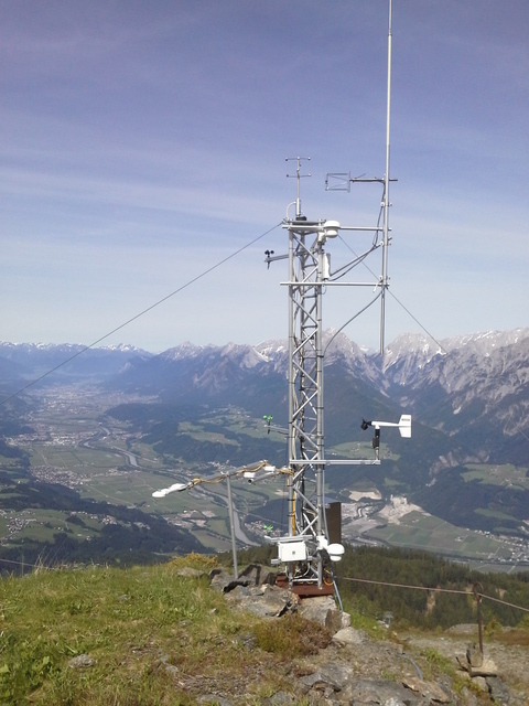
The mountain-top station CS-MT21 is located on Arbeserkogel, slightly below ridgetop on a steep west-facing slope. The 4-m high tower is a full energy-balance station and is instrumented with a sonic anemometer and a Krypton hygrometer at 4.7 m, as well as additional wind, temperature and humidity sensors at multiple levels.
Site characteristics
Coordinates: 47.320654˚N, 11.746592˚E (UTM: 707552.34E, 5244456.79 N)
Altitude: 2015 m MSL
Slope angle: 21˚
Slope orientation: 274˚
Surface characteristics: high-alpine vegetation
Status: operational since September 2014
Power supply: solar panel, fuel cell
Datalogger: CR3000
History/logbook: logbook and data availability
Instrumentation
| Instrument | Height | Serial number | Notes |
|---|---|---|---|
| Turbulence | |||
| METEK uSonic3 | 4.7 m | 0105123843 | Angle to true north: 6˚ |
| Campbell KH20 | 4.7 m | 1735 | until 2 June 2017 Path length: 0.01254 Path separation: 0.3551 xkw: -0.189 ln(mV)m3/g Intercept: 3946 mV since 2 June 2017 Path length: 0.0124 Path separation: 0.3551 xkw: -0.187 ln(mV)m3/g Intercept: 3508 mV Path separation: |
| Temperature/Humidity | |||
| Rotronic HC2-S3 "1m" | 0.48 m | ||
| Rotronic HC2-S3 "2m" | 1.90 m | dismounted | |
| Rotronic HC2-S3 "3m" | 3.95 m | 20467243 | |
| Wind | |||
| Cup anemometer | 0.55 m | dismounted 2021-09-18 | |
| Cup anemometer | 1.90 m | ||
| Cup anemometer | 3.95 m | ||
| Young wind monitor | 2.00 m | ||
| Pressure | |||
| Setra 278 | 5320479 | in logger box | |
| Precipitation/Snow | |||
| SR50A | 4899 | ||
| Radiation | |||
| CNR4 | 0.90 m | 110706 | SWd: 15.25 uV/Wm2 SWu: 13.80 uV/Wm2 LWd: 14.89 uV/Wm2 LWu: 13.48 uV/Wm2 |
| Soil | |||
| Heat Flux Plate HFP01 | 10 cm | 004332 | 63.9 uV/Wm2 |
| Campbell 107 Temp probe | 5 cm | ||
| Campbell 107 Temp probe |
Datasets
- RAWDATA
- since JUN.2025 Uncorrected 1-min raw data, no quality checks applied
- RAWDATAU25
- until JUN.2025 Uncorrected 1-min raw data, no quality checks applied
- RADIAT1
- 1-min radiation data after applying the respective calibration coefficients to the uncorrected raw data; no quality checks applied
- EDIRE_L1
30-min turbulence statistics (former processing with Edire)
Processed turbulence data with an averaging interval of 30 min (processing was performed using EdiRe) Processing includes despiking; double-rotation of the wind components; detrending with a recursive filter and a time constant of 200 s; and applying frequency-response corrections, heat-flux corrections for humidity effects, oxygen corrections for KH20, and WPL corrections. The datafile contains several quality flags.
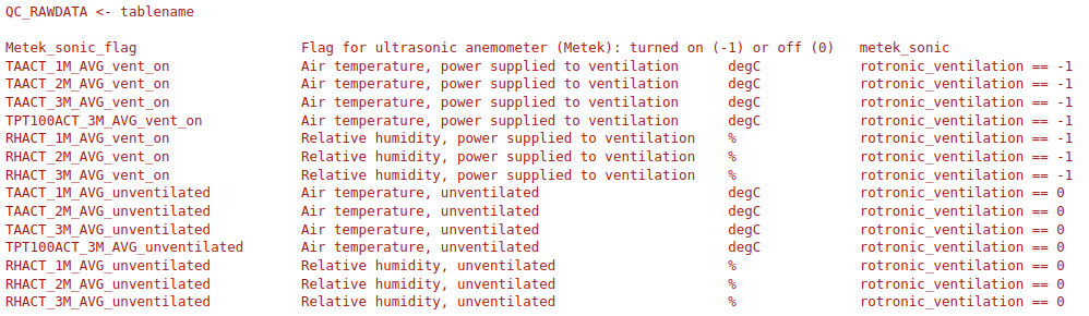
- QC RAW
- for creation rules see picture: Rule_QC_RAW
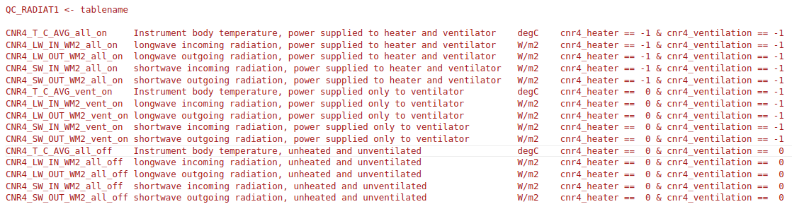
- QC RADIAT1
- for creation rules see picture: Rule_QC_RAD1
- ECPY_30MIN
- 30-min turbulence statistics (processed with ECpy) COLUMNDESCRIPTION
- ECPY_3MIN
- 3-min turbulence statistics (processed with ECpy) COLUMNDESCRIPTION