TAWES UIBK
CATEGORY
TAWES-UIBK is a routine meteorological station operated by Zentralanstalt für Meteorologie und Geodynamik (ZAMG, Vienna;) in cooperation with the Department of Atmospheric and Cryospheric Sciences (ACINN, Universität Innsbruck;). Its data contribute to the third longest meteorological series in Austria (since 1777) though having been relocated to different sites in and around the city of Innsbruck. The station is categorized as a so-called "Teilautomatische Wetterstation” (semi-automatic weather station, see section maintenance).
Note: TAWES-UIBK is one of the two routine meteorological stations operated in the area of Innsbruck. The other one is named INNSBRUCK-FLUGHAFEN (WMO-Station number 11121) and is located at Innsbruck airport i.e. outside the town itself.
LOCAL ENVIRONMENT
Innsbruck is located at the relatively flat bottom (570 to 580 m asl) of the W- E oriented Inn Valley in between mountain crests up to ca. 2500 m (north) and 2300 m (south), respectively. The surrounding slopes are quite forested up to 1700 to 1900 m with alpine meadows and rocks higher up. By 2016 Innsbruck hosted about 131000 inhabitants living within an area of about 35km 2 . The valley bottom around the town itself is mostly in agricultural use. The meteorological regime is strongly influenced by thermally driven valley winds developing along the major valley (W-E) and along a side valley (Wipp Valley, N-S), the latter also being known to initiate episodically strong southerly Foehn. Being basically situated at the valley bottom, cold pools and associated temperature inversions can frequently develop during winter. Climatological conditions are characterized by an average air temperature of 8.9 °C and mean annual precipitation of 883 mm (1971-2000, for other parameters or periods see http://www.zamg.ac.at).
STATION IDENTIFIERS
| Name: | INNSBRUCK-UNIVERSITÄT |
|---|---|
| ZAMG-Station Number: | |
| 11803 | |
| Synop-Station Number: | |
| 11320 | |
SENSOR POSITIONS (status 13 Feb 2018)
TAWES-UIBK is nominally located at 47.1536° N, 11.2303° E and 578 m asl., which in strict sense is valid for site „Schöpfstraße 45“, where measurements were taken since 1970. In 2006, however, part of the station was moved to another University building (Innrain 52f (ACINN), ca. 600 m north of Schöpfstraße 45, see map).
The exact positions of sensors being relevant for this data set are:
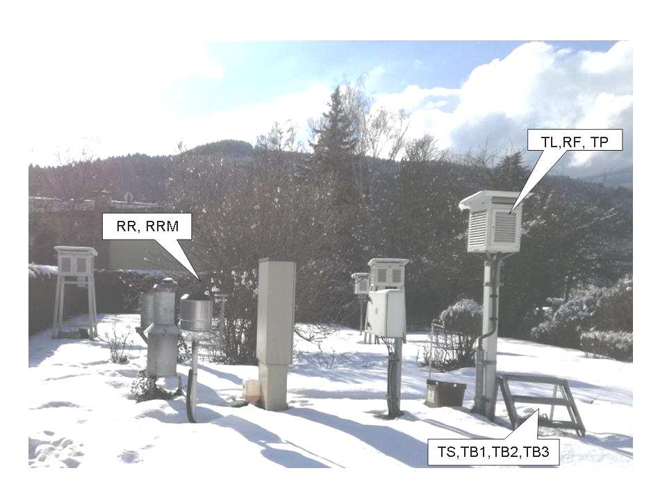
- Air temperature and humidity, precipitation and soil temperatures (parameters TL,TS,TB1,TB2,TB3,TP,RF,RR,RRM): Schöpfstraße 45, 47.2598503455° N, 11.3842340249° E, 579.2 m asl. (i.e., height of TL/RF sensors in screen 2.15 m agl)
- Air pressure (parameter P): ACINN buiding, 9th floor, room 6DG17, 47.2641314026° N, 11.3852435452° N, 609.5 m asl.
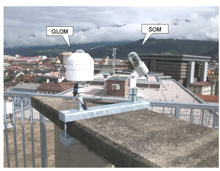
- Solar incoming radiation (GLOM),Sunshine duration (SOM): platform at ACINN- rooftop, 47.2642959009° N,11.3851982977° E, 615.0 m asl.
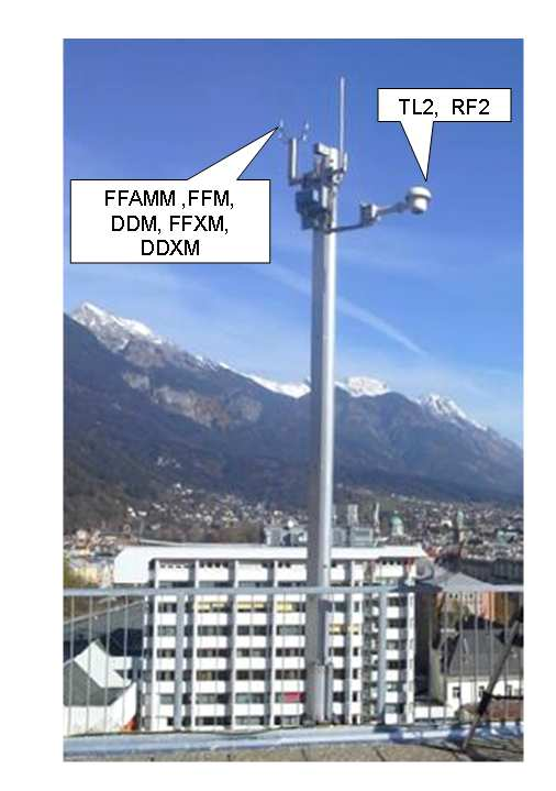
- Air temperature and humidity (TL2,RF2): mast at ACINN-rooftop, 47.26455958° N, 11.38522625! E, 617.0 m asl.
- Wind speed and -direction (parameters FFAMM,FFM, DDM, FFXM, DDXM): mast at ACINN-rooftop 47.26455958° N, 11.38522625° E, 617.7 m asl.
Note: these coordinates are deduced from GNSS measurements performed on 13 Feb 2018 using Trimble R8 and elevations are given as “Austrian Gebrauchshoehe” (referenced to mean sea level Triest/Adria, 1875). See table at the end for conversion to other references.
STATION INSTRUMENTATION (status since 29 Aug 2017)
- Air temperature (TL): Logotronic temperature sensor, mounted in small Stevenson screen 2.15 m above grass surface (Schöpfstraße 45) and artificially ventilated
- Air temperature (TL2): Logotronic temperature sensor, mounted in artificially ventilated Rotronic housing (mast at ACINN rooftop)
- Rel. humidity (RH): Rotronic Hygroclip sensor , mounted in small Stevenson screen 2.15 m above grass surface (Schöpfstrasse 45) and artificially ventilated
- Rel. humidity (RH2): Rotronic Hygroclip sensor , mounted in artificially ventilated Rotronic housing (mast at ACINN rooftop)
- Precipitation (RR, RRM): MPS TRWS 503 tipping bucket precipitation gauge and Thies 5.4103.10.000 precipitation monitor, mounted at 1.5 m above grass surface (Schöpfstraße 45)
- Soil temperatures (TB1, TB2, TB3): Logotronic temperature sensors, buried at depths -10cm, -20cm and -50 cm in soil below grass (Schöpfstraße 45), ca. 1 m next to Stevenson screen
- Near-surface temperature (TS): Logotronic temperature sensor, mounted at +5 cm above surface, ca. 1 m distant to Stevenson screen (Schöpfstraße 45)
- Solar incoming radiation (GLOM): Schenk 8101 (Schenk, Wien) Sternpyranometer sensor, mounted on concrete platform at ACINN rooftop, artificially ventilated and heated
- Sunshine duration (SOM): Haenni Solar sensor , mounted on concrete platform at ACINN rooftop
- Air presssure: Meteolabor BM35 sensor , mounted in enclosure within ACINN building (Bruno-Sander-Haus, 9th floor, room 6DG17)
- Wind speed and –direction (FFAMM,FFM, DDM, FFXM, DDXM): T hies 2D-ultrasonic sensor, mounted on top of a mast at the rooftop of ACINN building, since 09April2018 replaced by ThiesUS2D Compact.
The data are stored onto a Gealog SG datalogger (http://www.logotronic.at).
Some more details of the set up of sensors at the two TAWES-measurements sites may be judged from the following photographs:
ACINN rooftop (photo taken by F. Obleitner 31.10.2017):
Schöpfstraße 45 (photo taken by M. Graus 13.02.2018):
MAINTENANCE and DATA PROCESSING:
Sensors are scanned in 10 sec intervals, except those for radiation and wind (2 sec) and sunshine (1 sec), respectively. In general the database holds 10-minute (arithmetic) averages or 10-minute totals (precipitation and sunshine) calculated from scans, while wind speed and direction are given as 10-minute vector averages (FFM and DDM).
Following the concept of TAWES i.e., Teilautomatische Wetterstation", there is no regular maintenance of the station by an observer. However, ZAMG subjects the raw data to automatic quality control immediately after transmission and in case of detected problems nominated persons are informed to check and solve the problem. Beyond that the station is regularly serviced at least once a year by technical staff of ZAMG.
The transmitted data are subject to extended quality control and are transfered to the ZAMG-Sybase data base, finally.
HISTORICAL NOTES
TAWES-UIBK is the current representative of a series of weather stations in Innsbruck providing long-term routine meteorological measurements and observations. It thus contributes to the third longest meteorological series in Austria (since 1777). The records evolved from several stations at different sites within the city of Innsbruck. TAWES-UIBK is operated in its current setting since 2006 (split sites and based on ACINN-ZAMG cooperation).
OVERVIEW on average conditions and performance of the station:
Height of TAWES sensors referenced to different standards (based on GNSS measurements 13Feb2018)
| Parameter | TL,RF | P | FFAMM, FFM, FFXM, DDM, DDXM | TL2, RF2 | GLOM, SOM | RR, RRM | unit |
| Latitude (WGS84) | 47.259850 | 47.264131 | 47.264296 | 47.264296 | 47.264296 | 47.259850 | [deg N] |
| Longitude (WGS84) | 11.384234 | 11.385244 | 11.385198 | 11.385198 | 11.385198 | 11.384234 | [deg E] |
| Height (Austrian Gebrauchshöhe) | 579.2 | 609.5 | 617.7 | 617.1 | 615.2 | 578.6 | [m] |
| Height (Bessel, BMN 28) | 580.1 | 610.4 | 618.6 | 618.1 | 616.1 | 579.5 | [m] |
| Height (WGS84) | 628.4 | 658.7 | 666.8 | 666.3 | 664.3 | 627.7 | [m] |
| Height (EGM96) | 580.0 | 610.3 | 618.4 | 617.9 | 615.9 | 579.3 | [m] |
Calibration Factors
glo(mV) -> glo(W)
2019.09.10 13:50 – 2021.09.16 10:00 ---- Faktor 10,20
2021.09.16 10:00 – 2023.07.17 10:00 ---- Faktor 15,51
since 2023.07.17 10:00 ---- Faktor 14,07 (Sensornumber 5021)
calculation formula: glo(W)=(glo(mV) / glofak) * 1000
LINKS
FOEHN
The probability [0-1] that foehn occurs at a particular time is determined using a machine learning method "mixture models", which is described in Plavcan et al (2014). Classification is typically very sharp with probabilities close to 0 (no foehn) or 1 (foehn). If you are only interested in a binary yes/no classification, use 0.5 as a threshold. Probabilities clearly above 0.5 but not close to 1 typically indicate situations when foehn air and nocturnally-cooled air from tributary valleys and slopes mix.